

Building Map::Tube::<*> maps, a HOWTO: routing relative reality
The previous post focused on adding more lines to the network and adding colour to those lines. This time, we’ll add another line, but now the map will better match reality. This will allow us to start finding routes between stations on the network.
Building complexity
It’s time to get a bit trickier. In the real tram network in Hannover, the
main hub is actually the station Kröpcke and not Hauptbahnhof as we’ve
been using so far. Therefore, if we want to add further lines, we’ll have
to add this station and route the lines through it correctly. Doing so
allows us to do some cool things, like planning routes between seemingly
disjoint parts of the network.
The plan right now is to add Linie 4 from Garbsen to
Roderbruch.1 Here are the stations we want to add
along with their IDs and their station links:
| Station | ID | Links |
|---|---|---|
| Garbsen | H10 | H11 |
| Laukerthof | H11 | H10, H12 |
| Kröpcke | H12 | H11, H13, H3, H4, H7 |
| Kantplatz | H13 | H12, H14 |
| Roderbruch | H14 | H13 |
As in previous posts, I’ve continued the numbering from where I left off.
This time, Garbsen is the westernmost station along Linie 4 and hence
the “first” one along that line.
Looking at the links we have for Kröpcke in the table, we can see that
things are getting more complicated, especially at this particular station.
Since this node is so central to the network, we expect complexity to be
concentrated here. To manage this increase in complexity we’ll continue
using tests to guide the map’s evolution. Also, note that the links
connecting Laatzen and Allerweg to Hauptbahnhof will need to change
because these stations will now be connected to Kröpcke.
Many more much smaller steps
To start making these changes, we’ll need some tests. Fortunately, we
already have a good structure in t/map-tube-hannover.t that we can build
upon.
What’s the smallest incremental change that we can think of? Well, the network should now have three lines, so we update the “number of lines” test to check for that condition:
my $num_lines = scalar @{$hannover->get_lines};
is( $num_lines, 3, "Number of lines in network correct" );
Running the test file, we see that this will cause the first test failure:
$ prove -lr t/map-tube-hannover.t
t/map-tube-hannover.t .. 1/?
#   Failed test 'Number of lines in network correct'
#   at t/map-tube-hannover.t line 15.
#          got: '2'
#     expected: '3'
# Looks like you failed 1 test of 4.
and drive us to add the new line, Linie 4:
    "lines" : {
        "line" : [
            {
                "id" : "L1",
                "name" : "Linie 1",
                "color" : "red"
            },
            {
                "id" : "L7",
                "name" : "Linie 7",
                "color" : "blue"
            },
            {
                "id" : "L4",
                "name" : "Linie 4",
                "color" : "#f9a70c"
            }
        ]
    },
Here I’ve used an RGB colour for the line to show how this variant of specifying colour works. I found the colour by loading the PDF of the Üstra “Netzplan U” into Gimp and using the colour picker tool.
Managing expectations
From prior experience, we expect the tests to continue to fail, but for a different reason:
$ prove -lr t/map-tube-hannover.t
t/map-tube-hannover.t ..     # Line id L4 consists of 0 separate components

    #   Failed test 'Hannover'
    #   at /home/cochrane/perl5/perlbrew/perls/perl-5.38.3/lib/site_perl/5.38.3/Test/Map/Tube.pm line 196.
    # Line id L4 defined but serves no stations (not even as other_link)

    #   Failed test 'Hannover'
    #   at /home/cochrane/perl5/perlbrew/perls/perl-5.38.3/lib/site_perl/5.38.3/Test/Map/Tube.pm line 196.
    # Looks like you failed 2 tests of 14.
These errors are what we expect: the validation tests are telling us that
Linie 4 isn’t connected to anything and doesn’t have a station attached to
it.
To build the new line incrementally, we’ll first add only the stations from
Garbsen to Kröpcke. Then we’ll connect the new line to the network by
connecting Kröpcke to Hauptbahnhof. Later, we’ll add the remaining
stations.
To begin, add these station entries after Misburg:
            {
                "id" : "H10",
                "name" : "Garbsen",
                "line" : "L4",
                "link" : "H11"
            },
            {
                "id" : "H11",
                "name" : "Laukerthof",
                "line" : "L4",
                "link" : "H10,H12"
            },
            {
                "id" : "H12",
                "name" : "Kröpcke",
                "line" : "L1,L4,L7",
                "link" : "H3,H11"
            }
Running the test file gives this error:
$ prove -lr t/map-tube-hannover.t
t/map-tube-hannover.t ..     # Not every station reachable from every other station -- map has 2 separate components; e.g., stations with ids H1//H10

    #   Failed test 'Hannover'
    #   at /home/cochrane/perl5/perlbrew/perls/perl-5.38.3/lib/site_perl/5.38.3/Test/Map/Tube.pm line 196.
    # Looks like you failed 1 test of 14.
That’s very odd. That wasn’t an error I was expecting after this change. After all, the new line should connect to the previously defined lines.
What can the message
map has 2 separate components; e.g., stations with ids H1//H10
mean? How could we debug this situation?
Visual debugging
One thing we can do is to convert the map into an image with map2image.pl
and see if anything looks out of place:
$ perl bin/map2image.pl
Running the above command generates this image:
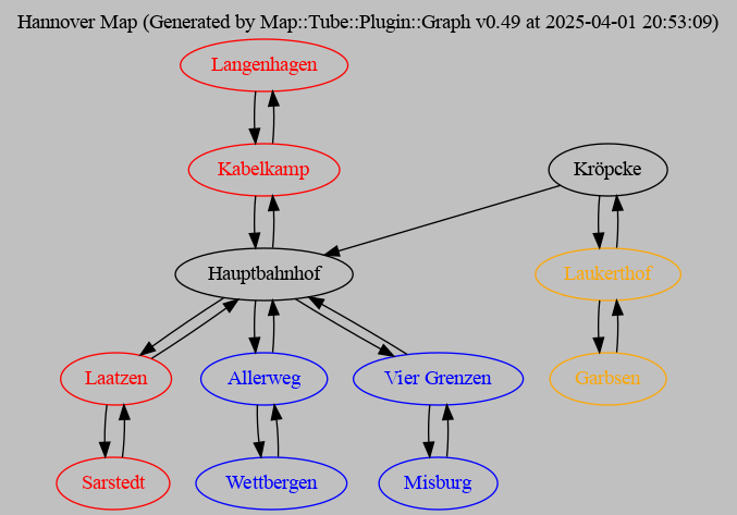
The problem is much clearer now! We can see that although there’s a link
from Kröpcke to Hauptbahnhof, there’s no link from Hauptbahnhof back
to Kröpcke. Adding that link (i.e. H12) to Hauptbahnhof:
            {
                "id" : "H3",
                "name" : "Hauptbahnhof",
                "line" : "L1,L7",
                "link" : "H2,H4,H7,H8,H12"
            },
gets the test suite to pass again:
$ prove -lr t/map-tube-hannover.t
t/map-tube-hannover.t .. ok
All tests successful.
Files=1, Tests=4,  0 wallclock secs ( 0.03 usr  0.00 sys +  0.54 cusr  0.06 csys =  0.63 CPU)
Result: PASS
Great!
Threading the new line through the network
Now we’re in a position to add the remaining stations on Linie 4. We
drive this change by adding a route from Garbsen to Roderbruch to our
routes tests. This then checks that these stations are part of the network:
my @routes = (
    "Route 1|Langenhagen|Sarstedt|Langenhagen,Kabelkamp,Hauptbahnhof,Laatzen,Sarstedt",
    "Route 4|Garbsen|Roderbruch|Garbsen,Laukerthof,Kröpcke,Kantplatz,Roderbruch",
    "Route 7|Wettbergen|Misburg|Wettbergen,Allerweg,Hauptbahnhof,Vier Grenzen,Misburg",
);

ok_map_routes($hannover, \@routes);
This test will hopefully fail because we haven’t added the Roderbruch
station yet:
$ prove -lr t/map-tube-hannover.t
t/map-tube-hannover.t .. 1/? Map::Tube::get_node_by_name(): ERROR: Invalid Station Name [Roderbruch]. (status: 101) file /home/cochrane/perl5/perlbrew/perls/perl-5.38.3/lib/site_perl/5.38.3/Map/Tube.pm on line 897
# Tests were run but no plan was declared and done_testing() was not seen.
# Looks like your test exited with 255 just after 3.
Expectations met again! Failing for the right reason means we’re on the right track.2
To continue, we add the remaining stations along Linie 4 and update the
list of links for Kröpcke to link to the station Kantplatz:
            {
                "id" : "H12",
                "name" : "Kröpcke",
                "line" : "L1,L4,L7",
                "link" : "H3,H11,H13"
            },
            {
                "id" : "H13",
                "name" : "Kantplatz",
                "line" : "L4",
                "link" : "H12,H14"
            },
            {
                "id" : "H14",
                "name" : "Roderbruch",
                "line" : "L4",
                "link" : "H13"
            }
Running the test suite gives:
$ prove -lr t/map-tube-hannover.t
t/map-tube-hannover.t .. 1/? Map::Tube::get_node_by_name(): ERROR: Invalid Station Name [Kröpcke]. (status: 101) file /home/cochrane/perl5/perlbrew/perls/perl-5.38.3/lib/site_perl/5.38.3/Test/Map/Tube.pm on line 1434
# Tests were run but no plan was declared and done_testing() was not seen.
# Looks like your test exited with 255 just after 3.
Erm, what?? I expected this test to pass. Unfortunately, we got the error
Invalid Station Name [Kröpcke]
What’s going on here?
Schei� Encoding
As is my wont, this led me down quite the rabbit hole. Yes, another one. To cut a very long story short, the issue here is that the station name contains a non-ascii character, in particular the umlaut ‘ö’.3 If we change the route test to
"Route 4|Garbsen|Roderbruch|Garbsen,Laukerthof,Kroepcke,Kantplatz,Roderbruch",
and update the station entry in the map file:
            {
                "id" : "H12",
                "name" : "Kroepcke",
                "line" : "L1,L4,L7",
                "link" : "H3,H11,H13"
            },
so that they use oe in place of ö, then the test suite will
pass:4
$ prove -lr t/map-tube-hannover.t
t/map-tube-hannover.t .. ok
All tests successful.
Files=1, Tests=4,  1 wallclock secs ( 0.03 usr  0.00 sys +  0.58 cusr  0.06 csys =  0.67 CPU)
Result: PASS
I first mentioned this behaviour in an issue in
Map::Tube::Frankfurt.
It seems that the Map::Tube version I’m using here (4.03) doesn’t always
process UTF-8 input correctly. I haven’t yet worked out the exact reason
for this, hence the only way is to avoid umlauts and the sharp-s (ß) and use
their ASCII-compatible versions. For German, this means that ä becomes ae,
ö becomes oe, ü becomes ue, and ß becomes ss.5
What’s weird here is that most of the validation tests work. It’s only as soon as one has a non-ASCII character like an umlaut or a sharp-s (ß) in the route name (at least for German maps) that problems seem to appear.
Since we’ve extended the network and now have a working configuration, it’s a good time for a commit:
$ git commit -m "Add Linie 4 from Garbsen to Roderbruch via Kröpcke" share/hannover-map.json t/map-tube-hannover.t
[main 22d482e] Add Linie 4 from Garbsen to Roderbruch via Kröpcke
 2 files changed, 38 insertions(+), 2 deletions(-)
If you convert the map to an image, you’ll find that everything is connected:
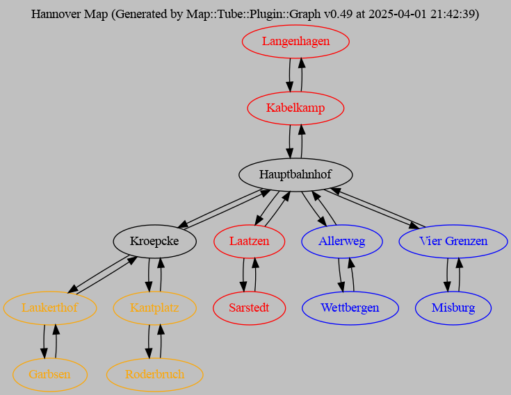
The lines do seem to be a bit jumbled up in the graph now, but that’s just an artefact of generating this graph automatically.
Keeping a critical eye open
Looking at this graph made me realise something: it’s wrong.
But Paul! Our tests are passing, it must be correct!
The thing is, the expectations in our tests are incorrect and we need to fix
them. If you compare the Üstra “Netzplan
U”
with the graph above, then you’ll find that Laatzen and Allerweg should
connect to Kröpcke and not to Hauptbahnhof as they are currently.
How do we solve this issue? We update the expectations in our routes tests. These tests now look like so:
my @routes = (
    "Route 1|Langenhagen|Sarstedt|Langenhagen,Kabelkamp,Hauptbahnhof,Kroepcke,Laatzen,Sarstedt",
    "Route 4|Garbsen|Roderbruch|Garbsen,Laukerthof,Kroepcke,Kantplatz,Roderbruch",
    "Route 7|Wettbergen|Misburg|Wettbergen,Allerweg,Kroepcke,Hauptbahnhof,Vier Grenzen,Misburg",
);

ok_map_routes($hannover, \@routes);
where, if you look closely, you’ll notice that we’ve squashed Kroepcke
between Hauptbahnhof and Laatzen and Allerweg, respectively:6
my @routes = (
    "Route 1|Langenhagen|Sarstedt|Langenhagen,Kabelkamp,Hauptbahnhof,Kroepcke,Laatzen,Sarstedt",
                                                                     ^^^^^^^^^
    "Route 4|Garbsen|Roderbruch|Garbsen,Laukerthof,Kroepcke,Kantplatz,Roderbruch",
    "Route 7|Wettbergen|Misburg|Wettbergen,Allerweg,Kroepcke,Hauptbahnhof,Vier Grenzen,Misburg",
                                                    ^^^^^^^^^
);
Getting by with a little help from our tests
The test suite will now fail right royally. However, the routes test from
Test::Map::Tube gives us lots of informative output about what went wrong.
We thus get many hints about how to correct things.
$ prove -lr t/map-tube-hannover.t
t/map-tube-hannover.t .. 1/?
#   Failed test 'Route 1'
#   at t/map-tube-hannover.t line 23.
#          got: 'Langenhagen (Linie 1)
# Kabelkamp (Linie 1)
# Hauptbahnhof (Linie 1, Linie 7)
# Laatzen (Linie 1)
# Sarstedt (Linie 1)'
#     expected: 'Langenhagen (Linie 1)
# Kabelkamp (Linie 1)
# Hauptbahnhof (Linie 1, Linie 7)
# Kroepcke (Linie 1, Linie 4, Linie 7)
# Laatzen (Linie 1)
# Sarstedt (Linie 1)'

#   Failed test 'Route 7'
#   at t/map-tube-hannover.t line 23.
#          got: 'Wettbergen (Linie 7)
# Allerweg (Linie 7)
# Hauptbahnhof (Linie 1, Linie 7)
# Vier Grenzen (Linie 7)
# Misburg (Linie 7)'
#     expected: 'Wettbergen (Linie 7)
# Allerweg (Linie 7)
# Kroepcke (Linie 1, Linie 4, Linie 7)
# Hauptbahnhof (Linie 1, Linie 7)
# Vier Grenzen (Linie 7)
# Misburg (Linie 7)'
# Looks like you failed 2 tests of 5.
t/map-tube-hannover.t .. Dubious, test returned 2 (wstat 512, 0x200)
Failed 2/5 subtests
By the way: converting the map to an image with map2image.pl is very
helpful in debugging connection-related problems such as those appearing in
the test failures above.
To solve these errors, we need to update Hauptbahnhof to look like the
following (we remove H4 and H7 as they should link to Kröpcke):
            {
                "id" : "H3",
                "name" : "Hauptbahnhof",
                "line" : "L1,L7",
                "link" : "H2,H8,H12"
            },
and Kröpcke to look like this (we add in H4 and H7):
            {
                "id" : "H12",
                "name" : "Kroepcke",
                "line" : "L1,L4,L7",
                "link" : "H3,H4,H7,H11,H13"
            },
as well as Laatzen, where we replace H3 (Hauptbahnhof) with H12
(Kröpcke):
            {
                "id" : "H4",
                "name" : "Laatzen",
                "line" : "L1",
                "link" : "H5,H12"
            },
and Allerweg (again, H12 replaces H3):
            {
                "id" : "H7",
                "name" : "Allerweg",
                "line" : "L7",
                "link" : "H6,H12"
            },
The tests should now pass:
$ prove -lr t/map-tube-hannover.t
t/map-tube-hannover.t .. ok
All tests successful.
Files=1, Tests=4,  1 wallclock secs ( 0.03 usr  0.01 sys +  0.54 cusr  0.04
csys =  0.62 CPU)
Result: PASS
… and they do! Yay!
Converting the map into an image with map2image.pl, you should see this
output:
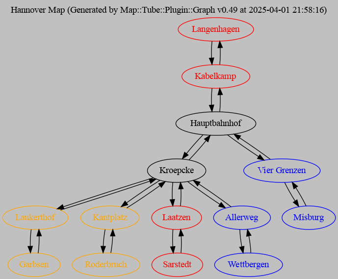
where most of the connections go through Kröpcke as we’d expect for such a
central node.
What’s nice about the network graph now is that it’s starting to look more and more like the actual network graph in the Üstra “Netzplan U”.
Since we’ve reached a new stable state of the code, let’s commit this change and move on.
$ git commit share/hannover-map.json t/map-tube-hannover.t -m "Fix connections through Kröpcke
>
> Routes 1 and 7 in the tests were no longer correct as they didn't reflect
> reality.  The stations Allerweg and Laatzen were actually connected to
> Kröpcke and not to Hauptbahnhof.  This change fixes the issue and ensures
> the network better reflects the actual tram network in Hannover."
[main f931ec1] Fix connections through Kröpcke
 2 files changed, 6 insertions(+), 6 deletions(-)
Getting to the route of the problem
Now that our map has gained more complexity, it means that we can start to
do interesting things. Map::Tube is, after all, a routing framework.
Thus, we can start planning routes across lines, not only within lines as
we’ve been doing so far. In other words, we can now look for a route
requiring us to change trains and transfer to another line. To search for
routes, we use the get_shortest_route() method.
Let’s build a small program that we can use to find routes within our
network. Then we can try finding a route from Garbsen (on Linie 4) to
Sarstedt (on Linie 1) as an example.
I’m going to avoid creating tests for the program and I’ll skip input validation7 so that we can get things up and running quickly. These skipped steps are left as an exercise for the reader. 😉
Create a file called bin/get_route.pl in your favourite editor and enter
this code:
use strict;
use warnings;

use lib qw(lib);

use Map::Tube::Hannover;


# grab the start and end stations of the route
my $from = $ARGV[0];
my $to = $ARGV[1];

# show how to get from one to the other
my $hannover = Map::Tube::Hannover->new;
print $hannover->get_shortest_route($from, $to), "\n";

# vim: expandtab shiftwidth=4
This should be sufficient for our needs. As with map2image.pl, we set the
lib path explicitly so that we don’t have to mention -I lib on the
command line. Then we import the Map::Tube::Hannover module. We grab the
start and end stations of our route from the @ARGV array because we’re
supplying this information via command line arguments. Thus, we’ll run the
program like so:
$ perl get_route.pl 'start station name' 'end station name'
We then create an instance of a Map::Tube::Hannover object and call the
get_shortest_route() method on that. The names of our start and end
stations are passed as arguments to get_shortest_route(). We print the
result of this method call to the terminal, thus showing the route to take.
Let’s see it in action. In our first example, we want to find a route from
Garbsen to Sarstedt:
$ perl bin/get_route.pl Garbsen Sarstedt
Garbsen (Linie 4), Laukerthof (Linie 4), Kroepcke (Linie 1, Linie 4, Linie 7), Laatzen (Linie 1), Sarstedt (Linie 1)
That was easy, wasn’t it? Now we know that to get from Garbsen to Sarstedt,
we have to change trains at Kröpcke.
How do we handle stations with spaces in their names, such as Vier Grenzen? Simply add quotes around the name when calling the program:
$ perl bin/get_route.pl Garbsen 'Vier Grenzen'
Garbsen (Linie 4), Laukerthof (Linie 4), Kroepcke (Linie 1, Linie 4, Linie 7), Hauptbahnhof (Linie 1, Linie 7), Vier Grenzen (Linie 7)
This example highlights two options for the shortest route: one could change
to Linie 1 at Kroepcke and then change to Linie 7 at Hauptbahnhof,
or one could change directly to Linie 7 at Kroepcke. Both paths are
equivalent ways of getting from Garbsen to Vier Grenzen.
Cool!
That looks like a handy program to have around. Let’s add it to the repository and commit the change:
$ git add bin/get_route.pl
$ git commit -m "Add program to get a route from one station to another"
[main ff27347] Add program to get a route from one station to another
 1 file changed, 17 insertions(+)
 create mode 100644 bin/get_route.pl
Wrapping up
We’ve finally been able to use our module for what we intended it to do: find routes through the railway network. We’ve also seen that it’s useful to have a visual representation of the map as a debugging aid. Also, we’ve maintained our flow, using tests to drive new features and committing changes to Git as soon as the code achieves a suitable stable state.
In the final post in this series, we’ll see how to build connections between stations that aren’t connected directly.
Originally posted on https://peateasea.de.
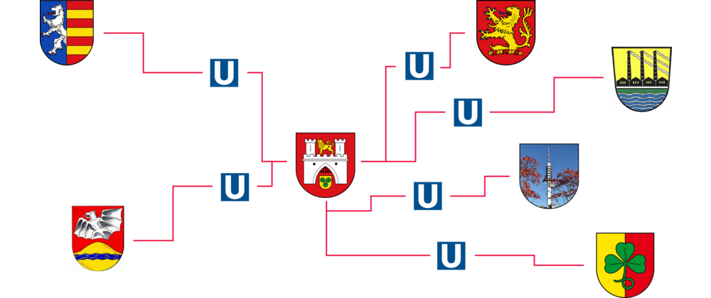
Image credits: Hannover coat of arms: Wikimedia Commons, U-Bahn symbol: Wikimedia Commons, Langenhagen coat of arms: Wikimedia Commons, Sarstedt coat of arms: Wikimedia Commons, Wettbergen coat of arms, Misburg coat of arms, Garbsen coat of arms, Telemax tower.
Thumbnail credits: Swiss Cottage Underground Station (Jubilee Line) by Hugh Llewelyn
-
It turns out that suburb of Roderbruch doesn’t have a coat of arms. One of its well-known landmarks is the Telemax tower, hence I used it to make a coat-of-arms-like image for this station in the article’s cover image. ↩︎
-
I really, honestly, didn’t intend that pun! ↩︎
-
In case you’ve ever wondered, the question mark inside a rotated square is called the replacement character and has the Unicode value U+FFFD. ↩︎
-
In German, umlauts can be written with their ASCII equivalents. In other words, one can write the umlauts ä, ö and ü as “ae”, “oe” and “ue”, respectively. ↩︎
-
Since I wrote the initial draft of this series, Mohammad has already fixed the issue. If you want to avoid the UTF-8 problems, then you’ll need to install
Map::Tubewith at least version 4.08. ↩︎ -
It turned out to be difficult to show a nice word diff of the change, so this was the best I could do to highlight what was added. ↩︎
-
Naughty me! Bad Paul! ↩︎
Tags
Feedback
Something wrong with this article? Help us out by opening an issue or pull request on GitHub

